
About Our Fine Art Reproductions and Frames
____________________________________________
AUTHENTIC PRINTS
We sell antique prints (the actual artifact!) as well as fine art reproductions of the maps in our collection. Select "Authentic Print" from the purchase options to purchase the real deal, an artifact produced years ago. Authentic prints are available when we have them. The website will indicate "sold out" if the authentic print is no longer available. Fine art reproductions of every image in our collection are always available.
Lead times: Unframed authentic prints are typically ready for shipment or pickup within a few days of order placement. Some authentic prints listed on our website must be brought in from other dealers. In those cases, additional days are required to get those prints to us before shipping or pickup can take place.
____________________________________________
FINE ART PRINTS/REPRODUCTIONS
Printing: We print in-house to control all aspects of print quality and consistency.
Printers: We exclusively utilize Epson commercial-grade Ultrachrome printers and pigment inks.
Papers: We print onto Epson Premium and Ultra-premium matte-finish papers engineered for Epson Ultrachrome printers.
Paper Sizes / Prices:
Small 8 1/2" x 11" Paper = $14.95
Studio 11" x 14" Paper = $19.95
Medium 13" x 19" Paper = $29.95
Intermediate 18" x 24" Paper = $49.95
Large 24" x 36" Paper = $69.95
Quality: Our fine art prints are museum-quality, no-fade, color-stable, acid-free, and archival.
Layout: All images are printed as large as possible onto the selected paper size. The original proportions of the image are maintained. No stretching to fill the paper occurs. Given that the proportions of each image rarely matches that of the paper, there is always white space around the image. Images are centered onto the paper as much as possible.
Watermarks: Watermarks will not be printed on reproduction fine art prints. Watermarks are displayed on website images only.
Lead times: Unframed prints are typically ready for shipment or pickup within a few days of order placement.
Pricing Policy: We reserve the right to change, lower, or increase the price of any item at any time. If we lower a price for an item, such as when we run a sale or put an item on clearance, we do not provide retroactive refunds or credits.
____________________________________________
FRAMING
Fabrication: All of our frames are 100% made in Cambridge, Massachusetts USA. We have a longstanding relationship with a local fine art framer who exclusively produces all of our frames.
Framing Types: We offer three types of framing, each with its own styles/colors.
Custom/Archival Framing
Economy/Non-Archival Framing
Studio/No Matting
Medium/No Matting Framing
Why choose Custom/Archival framing? We recommend Custom/Archival frames when framing any authentic print. All authentic prints can fade when exposed to direct or indirect sunlight. Custom/Archival frames feature UV-resistant glazing to protect antique images from fading. Custom/Archival frames feature acid-free mat boards and backing boards that will not damage authentic prints. Store bought frames typically do not use UV-resistant glass nor acid-free materials. A Custom/Archival frame is the best way to protect and display an antique print for the ages.
Why choose Economy/Non-Archival framing? Economy/Non-Archival frames are perfect for our fine art reproductions. Since our reproductions are archival (made with archival inks and acid-free papers), UV-resistant glazing nor acid-free boards are required to protect the reproduction. Economy/Non-Archival frames offer a sensible price point and affordable way to bring a framed image into any space.
Frame Prices: All frame prices listed below do not include the cost of any reproduction print, shipping, or sales tax. See any individual map page on our site to explore calculated total costs for print + frame + sales tax + shipping.
Custom/Archival Medium = $175
Custom/Archival Intermediate = $225
Custom/Archival Large = $275
Economy/Non-Archival Small (11" x 14") = $60
Economy/Non-Archival Medium (16" x 20") = $80
Studio/No Matting (11" x 14") = $50
Medium/No Matting (13" x 19") = $60
18" x 24" No Matting = $80 (available in store only)
Fine Art Reproduction Map + Frame = Total Framed Map Price:
Small Print ($14.95) + Economy/Non-Archival ($60) = $74.95
Small Print ($14.95) + Custom/Archival Frame ($125) = $139.95
Studio Print ($19.95) + Studio/No Matting ($50) = $69.95
Medium Print ($29.95) + Medium/No Matting ($60) = $89.95
Medium Print ($29.95) + Economy/Non-Archival ($80) = $109.95
Medium Print ($29.95) + Custom/Archival Frame ($175) = $204.95
Interm. Print ($49.95) + Economy/No Matting* ($80) = $129.95
Interm. Print ($49.95) + Custom/Archival Frame ($225) = $274.95
Large Print ($69.95) + Custom/Archival Frame ($275) = $344.95
Pricing Policy: We reserve the right to change, lower, or increase the price of any item at any time. If we lower a price for an item, such as when we run a sale or put an item on clearance, we do not provide retroactive refunds or credits.
Frame Sizes:
Medium/No Matting = 13" x 19"
**These sizes are approximate because we build each custom frame around the size of each map reproduction image size or authentic antique map size.
Frame Shipping: Small and Medium Fames are shipped in robust packaging with insurance. As of Jan 1, 2023, we no longer offer shipping of Intermediate and Large Frames. We continue to offer in-store pick up for any frame, regardless of size.
Framing Lead Times:
Custom/Archival Frames are hand-fabricated to order at our outside fine art framer's shop. They have a lead time of 2-3 weeks before they are ready for shipment or pick up.
Economy/Non-Archival Frames are hand-fabricated to order at our outside fine art framer's shop. They have a lead time of 1-2 weeks before they are ready for shipment or pick up.
Studio/No-Matting and Medium/No Matting Frames have their final assembly produced in house. They have a lead time of approximately 1 week or less before they are ready for shipment or pick up.
__________________________________________________
FRAME TYPES
We offer three types of framing, each with various styles.
Custom/Archival Framing
Economy/Non-Archival Framing
Studio/No Matting
Medium/No Matting Framing
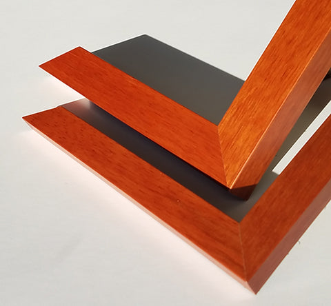
Custom/Archival Frames are constructed from painted wood with UV-resistant glazing to protect an antique map from fading. Custom/Archival frames feature acid-free mat boards and backing boards that will not damage the antique map. Each Custom/Archival frame comes with professional paper backing, hanging wire installed, and even a hook and a nail (see photo below). We offer a variety of styles of Custom/Archival frames.

Custom/Archival Frame: Black Basic
Smooth black with simple profile


Custom/Archival Frame: Black Stepped
Smooth black with tiered profile


Custom/Archival Frame: Cherry Finish
This frame has a reddish-brown color with wood texture. Two versions are photographed. The thinner/smaller profile is used with small and medium frames. The thicker/larger is used with intermediate and large frames.
Custom/Archival Frame: Walnut Finish
This frame is brown in color with wood texture. Two versions are photographed. The thinner/smaller profile is used with small and medium frames. The thicker/larger is used with intermediate and large frames.

Economy/Non-Archival Frames are constructed from painted with with plate glass. They are perfect for our reproduction maps. Since our fine art prints are archival (made with archival inks and acid-free papers), UV-resistant glazing nor acid-free boards are required to protect the reproduction. To keep costs down and offer the highest quality at the lowest price, Economy/Non-Archival frames are available in one style, black with a square profile. Each frame comes with claw hanger on the back.


Studio/No-Matting Frames accommodate our Studio 11" x 14" prints and do not include a mat. To keep costs down and offer the highest quality at the lowest price, Medium/No-Matting frames are available in one style, black with a square profile. Each frame comes with claw hanger on the back.


Medium/No-Matting Frames accommodate our Medium 13" x 19" prints and do not include a mat. To keep costs down and offer the highest quality at the lowest price, Medium/No-Matting frames are available in one style, black with a square profile. Each frame comes with claw hanger on the back.


Shipping, Pickups, Returns, and Policies
____________________________________________
Shipping
Shipping Unframed Fine Art Prints / Reproduction Maps
Small and Medium prints are shipped flat in plastic sleeves with rigid backing boards. Intermediate and larger prints are shipped rolled in rigid cardboard tubes with protective acid free paper linings.
Shipping Framed Maps
Frames are shipped in robust packaging with insurance.
Shipping Charges
Calculated rates are determined by the shipping carriers offered. Set rates and options are displayed during checkout.
Shipping Carriers
Shipping via the USPS and UPS are offered. Rates are calculated by the carriers.
International Shipping
We do not offer international shipping. We do ship to US territories and US Armed Forces Overseas addresses.
____________________________________________
Picking Up An Order
When placing an order, you have the option to pick up your order in person from our retail store. Orders will not be ready until after we contact you to confirm that your order is ready. We will call or email to notify you when your order is ready to be picked up. We will hold orders for 90 days. We are not responsible for orders not picked-up within 90 days. After 90 days from day of purchase, unclaimed orders may be returned to stock and payment may not be refunded.
Note: to ensure timely receipt of our pick up email notifications, please add info@wardmaps.com to your contacts.
____________________________________________
Returns & Defective Items
All sales are final. We do not accept exchanges nor returns on properly fulfilled and non-defective orders. We will replace or provide a credit for any defective item within 30 days of receipt of item. Please contact us regarding defective items. We will rectify any improperly fulfilled order. Please contact us regarding improperly fulfilled orders.
Items Damaged in Shipping
Though we use professional and robust packaging methods, damage of items in shipment is always a possibility. Hence, we typically ship items with shipping insurance at our cost. We will ask for a buyer's assistance in processing any claims against a shipper for items damaged in shipment. Once the claim has been resolved with the shipper, we will offer a replacement or credit to a buyer for the damaged item. If we did not ship with insurance, we will do our best to replace the item or issue a credit.
____________________________________________
Pricing Policy
We reserve the right to change, lower, or increase the price of any item at any time. If we lower a price for an item, such as when we run a sale or put an item on clearance, we do not provide retroactive refunds or credits.
Privacy Policy
All purchases made with WardMaps LLC are processed securely by our third party shopping cart and credit card processors. WardMaps LLC is never privy to credit card data inputted on this site. WardMaps never shares the names, emails, nor any personal data about our customers with anyone.