
Boston, Massachusetts 1842
Boston, Massachusetts 1842
Date: 1842
Publisher: Society for the Diffusion of Useful Knowledge (SDUK)
Size: 13.5" wide x 16.5" high
Source Collection: WardMaps LLC
Boston In Transit - The Book
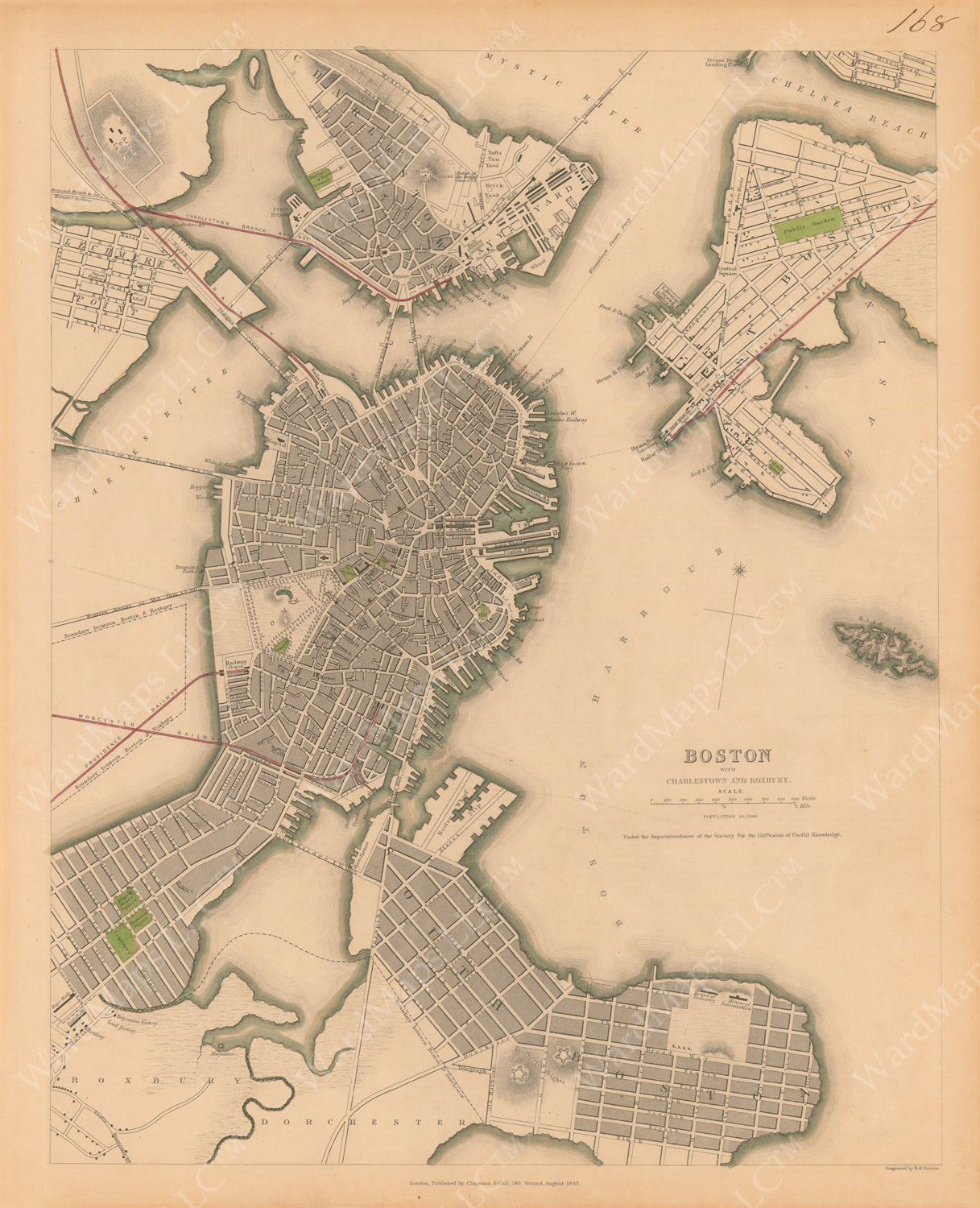
Figure 1.40 - Mapping Boston’s Connections, 1842
Less than a decade after the first steam railroad arrived on the Shawmut Peninsula, a map shows Boston tied to the mainland by three steam railroad lines. The combination railroad line and harbor ferry of the “Eastern Railway” connects East Boston with the Shawmut Peninsula. The “Lowell Railway,” parallel to Craigie’s Bridge, extends from Cambridge into Boston. The causeways of the “Worcester Railway” and “Providence Railway” cross like an “X” in the middle of the Back Bay, near the “Mill Dam” causeway (now Beacon Street). Beyond steam railroad lines, multiple bridges and ferry lines link Boston with surrounding communities.
Purchase This Item
Couldn't load pickup availability
Share
Collapsible content
About Our Fine Art Reproductions and Frames
____________________________________________
FINE ART PRINTS/REPRODUCTIONS
Printing: We print in-house to control all aspects of print quality and consistency.
Printers: We exclusively utilize Epson commercial-grade Ultrachrome printers and pigment inks.
Papers: We print onto Epson Premium and Ultra-premium matte-finish papers engineered for Epson Ultrachrome printers.
Paper Sizes / Prices:
Small 8 1/2" x 11" Paper = $14.95
Studio 11" x 14" Paper = $19.95
Medium 13" x 19" Paper = $29.95
Intermediate 18" x 24" Paper = $49.95
Large 24" x 36" Paper = $69.95
Quality: Our fine art prints are museum-quality, no-fade, color-stable, acid-free, and archival.
Layout: All images are printed as large as possible onto the selected paper size. The original proportions of the image are maintained. No stretching to fill the paper occurs. Given that the proportions of each image rarely matches that of the paper, there is always white space around the image. Images are centered onto the paper as much as possible.
Watermarks: Watermarks will not be printed on reproduction fine art prints. Watermarks are displayed on website images only.
Lead times: Unframed prints are typically ready for shipment or pickup within a few days of order placement.
Pricing Policy: We reserve the right to change, lower, or increase the price of any item at any time. If we lower a price for an item, such as when we run a sale or put an item on clearance, we do not provide retroactive refunds or credits.
Shipping, Pickups, Returns, and Policies
____________________________________________
Shipping
Shipping Unframed Fine Art Prints / Reproduction Maps
Small and Medium prints are shipped flat in plastic sleeves with rigid backing boards. Intermediate and larger prints are shipped rolled in rigid cardboard tubes with protective acid free paper linings.
Shipping Framed Maps
Frames are shipped in robust packaging with insurance.
Shipping Charges
Calculated rates are determined by the shipping carriers offered. Set rates and options are displayed during checkout.
Shipping Carriers
Shipping via the USPS and UPS are offered. Rates are calculated by the carriers.
International Shipping
We do not offer international shipping. We do ship to US territories and US Armed Forces Overseas addresses.
____________________________________________
Picking Up An Order
When placing an order, you have the option to pick up your order in person from our retail store. Orders will not be ready until after we contact you to confirm that your order is ready. We will call or email to notify you when your order is ready to be picked up. We will hold orders for 90 days. We are not responsible for orders not picked-up within 90 days. After 90 days from day of purchase, unclaimed orders may be returned to stock and payment may not be refunded.
Note: to ensure timely receipt of our pick up email notifications, please add info@wardmaps.com to your contacts.
____________________________________________
Returns & Defective Items
All sales are final. We do not accept exchanges nor returns on properly fulfilled and non-defective orders. We will replace or provide a credit for any defective item within 30 days of receipt of item. Please contact us regarding defective items. We will rectify any improperly fulfilled order. Please contact us regarding improperly fulfilled orders.
Items Damaged in Shipping
Though we use professional and robust packaging methods, damage of items in shipment is always a possibility. Hence, we typically ship items with shipping insurance at our cost. We will ask for a buyer's assistance in processing any claims against a shipper for items damaged in shipment. Once the claim has been resolved with the shipper, we will offer a replacement or credit to a buyer for the damaged item. If we did not ship with insurance, we will do our best to replace the item or issue a credit.
____________________________________________
Pricing Policy
We reserve the right to change, lower, or increase the price of any item at any time. If we lower a price for an item, such as when we run a sale or put an item on clearance, we do not provide retroactive refunds or credits.
Privacy Policy
All purchases made with WardMaps LLC are processed securely by our third party shopping cart and credit card processors. WardMaps LLC is never privy to credit card data inputted on this site. WardMaps never shares the names, emails, nor any personal data about our customers with anyone.